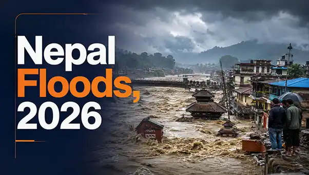
Nepal Floods, 2026
On 26 August 2026, a catastrophic flash flood struck the Nepal-Tibet border region, particularly the Bhote Koshi/Lhende Khola river system. Initial assessments indicate that an ice-rock/glacial avalanche caused a sudden surge of water, mud, ice and boulders downstream. The disaster devastated settlements and critical infrastructure in Nepal and Tibet.
The incident is significant for India because rivers such as the Kosi, Gandak and Karnali originate in or pass through Nepal before entering India. It highlights the increasing vulnerability of the Himalayas to compound disasters involving floods, landslides, glacier instability, GLOFs and avalanches.
What is a Flash Flood?
A flash flood is a sudden and rapid rise of water that occurs within a short period, leaving very little time for warning and evacuation. In the Himalayas, flash floods can be particularly destructive because of steep slopes, narrow valleys and high river gradients. They can carry huge quantities of boulders, mud, ice and debris, turning an ordinary flood into a destructive debris flow.
A Glacial Lake Outburst Flood (GLOF) occurs when water stored in a glacial lake is suddenly released due to moraine-dam failure, avalanches or lake overflow, causing destructive downstream flooding.
What Triggered the Nepal Flood?
Ice-Rock/Glacial Avalanche - The immediate trigger is suspected to have been a massive ice-rock avalanche/glacial collapse. The sudden movement of ice and rock displaced or blocked river water, producing a powerful downstream surge. Scientists have distinguished the event from an ordinary rainfall-induced flood.
Glacial and Permafrost Instability - Rising temperatures can cause glacier retreat and permafrost thaw. Permafrost acts as an ice-based binding material in mountain slopes; its degradation can weaken rock faces and increase the probability of rockfalls, avalanches and landslides.
Possible Weather Interaction - The event also raises questions about the interaction between unusual atmospheric conditions and already unstable high-altitude terrain. The important point is that climate-related changes can increase the probability of multiple hazards occurring together.
Reasons for Increasing Flood Vulnerability in the Himalayas
1. Natural Factors
The Himalayas are naturally vulnerable because they are young, tectonically active and geologically unstable mountains and make the region prone to earthquakes, landslides and rockfalls. Cloudbursts, intense monsoon rainfall and steep river gradients can generate high-velocity flash floods. Landslides may temporarily block rivers and their sudden breach can create flood waves. The 2015 Gorkha Earthquake and 2013 Kedarnath disaster illustrate these natural vulnerabilities.
The disaster was triggered by the collapse of a lower section of a Himalayan glacier, causing a destructive ice-rock avalanche and debris flow. Initially, the tremors were mistaken for a 4.4-magnitude earthquake, but United States Geological Survey (USGS) analysis of seismic waves and satellite imagery confirmed that they were caused by the glacial collapse and debris movement.
2. Man-Made Factors
Human activities have significantly increased the vulnerability of Himalayan settlements. Unscientific road construction, vertical hill-cutting, tunnelling, blasting and hydropower development can weaken slopes and disturb groundwater systems. Construction of buildings and infrastructure on active floodplains, river terraces and landslide-prone areas increases exposure to disasters. China is rapidly developing roads, tunnels, hydropower projects and border infrastructure in Tibet, including projects around the Himalayan river systems. Large dams and hydropower projects also raise concerns about downstream water flows, sediment movement and disaster risks for Nepal and India.
3. Governance & Regulatory Factors
Weak implementation of environmental and disaster-management regulations further increases vulnerability. Project-wise environmental clearances may fail to consider the cumulative impact of multiple roads, dams, tunnels and urban settlements within the same river basin.
Impact of the Flood -
The disaster resulted in significant loss of life, missing persons and displacement, along with extensive damage to settlements and critical infrastructure. Roads and bridges were washed away, affecting connectivity and rescue operations, while damage to hydropower and other infrastructure can create major economic losses. Since Himalayan rivers are transboundary, severe flooding in Nepal can potentially increase downstream risks for India, particularly in the Kosi, Gandak and Karnali river systems.
Legal Framework in India -
The primary legislation governing disaster management in India is the Disaster Management Act, 2005, which provides for disaster prevention, mitigation, preparedness, response, recovery and reconstruction. It establishes institutions such as the National Disaster Management Authority (NDMA), State Disaster Management Authorities (SDMAs) and District Disaster Management Authorities (DDMAs).
India’s Response -
India provided humanitarian assistance to Nepal and monitored possible downstream flood risks in Bihar and Uttar Pradesh. The disaster highlighted the need for stronger India-Nepal cooperation on transboundary rivers through real-time data sharing, flood forecasting, glacier monitoring and early-warning systems. Other countries and international organisations also extended humanitarian and technical assistance.